Resources - Original Data
These files encompass the original high-resolution data used as Figures and references in other publications. PDFs of these files are available for consortium members only.
Each file entry contains the filename (with filesize), a link to the publication that included the data, and a link to the page on this website where the publication is located. While the files are all posted as PDFs, each has layers preserved and can be opened and modified in a current version of Adobe Illustrator™.
-
Title: Facies Architectural Study of River-dominated Mouth Bar Deposits in a Crevasse Delta in the Cretaceous Ferron Notom Delta, South-Central Utah
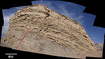
Figure 1 - Basemap showing the distribution of Ferron Notom delta outcrop
 (410KB)
Figure 2 - Google earth image of the study area (1.3MB)
Figure 3 - Basemap showing locations of measured sections (2.4MB)
Figure 4 - Basemap showing locations of photomosaics (2MB)
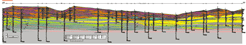
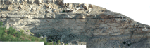
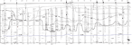
Figure 5 - Photomosaic and bedding diagram of panel 1 (1.1MB)
Figure 6 - Photomosaic and bedding diagram of panel 2 (1.9MB)
Figure 7 - Photomosaic and bedding diagram of panel 3 (1.6MB)
Figure 8 - Photomosaic and bedding diagram of panel 4 (1.3MB)
Figure 9 - Photomosaic and bedding diagram of panel 5 (1.1MB)
Figure 10 - Photomosaic and bedding diagram of panel 6 (899KB)
Figure 11 - Photomosaic and bedding diagram of panel 7 (526KB)
Figure 12 - Photomosaic and bedding diagram of panel 8 (610KB)
Figure 13 - Photomosaic and bedding diagram of panel 9 (1.4MB)
Figure 14 - Photomosaic and bedding diagram of panel 10 (1.1MB)
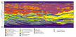
Figure 15 - Cross section a_a' (477KB)
Figure 16 - Cross section b_b' (470KB)
Figure 17 - Paleocurrent and clinoform data (416KB)
Figure 18 - Paleogeographic reconstruction of the study area (427KB)
Figure 19 - Paleogeographic reconstruction of the whole delta (2.2MB)
-
Title: Facies Architectural Study of Fluvial-Dominated Mouth Bar Deposits
Chen, Ella, Omar, Cameron, Apu
Referencing File: Construction of an Inertia-to Friction-Influenced Delta Front, Turonian Ferron Sandstone, UtahBedding Diagram for Photomosaic 2
(3.3MB)
Photomosaic 1 (2.3MB)
Photomosaic 2 (7.1MB)
-
Title: Measured Sections of Storm-Dominated Delta Front and Prodelta Facies
Referencing File: Thin-Bedded Reservoir Architecture of Storm-Dominated Delta Front and Prodelta Facies, Cretaceous Ferron Notom Delta, Utah
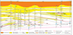
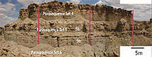 Parasequence 5A - Left Section (494KB)
Parasequence 5A - Middle Section (562KB)
Parasequence 5A - Right Section (507KB)
Parasequence 5B - Left Section (594KB)
Parasequence 5B - Middle Section (215KB)
Parasequence 5B - Right Section (528KB)
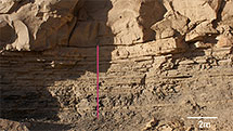 Parasequence 6 - Sample w/ Measured Section (922KB)
Parasequence 6 - Measured Section (569KB)
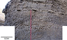 Parasequence 11 - Sample w/ Measured Section (4.5MB)
Parasequence 11 - Measured Section (633KB)
-
Title: Sweetwater Cross-Section (Review) (2.3MB)
Referencing File: Response to accommodation change in channel belt distribution, floodplains, and paleosols: Cretaceous Ferron-Notom Delta, Utah -
Title: Lower Delta Plain Distributary Channel Systems
Referencing File: Facies Architecture Branching Pattern, and Paleodischarge of a Lower Delta-plain Distributary Channel System in the Cretaceous Ferron Notom Delta, Southern Utah, U.S.ABasemap of the study area
(429KB)
Cross section 1_ Correlation of measured sections (452KB)
Cross section 1_Bedding diagram (1.7MB)
Cross section 1_photomosaic (17.3MB)
Cross section 2_Bedding diagram (1MB)
Cross section 2_Correlation of measured sections (427KB)
Cross section 2_Photomosaic (34.2MB)
Cross section 3_Bedding diagram (994KB)
Cross section 3_Correlation of measured sections (454KB)
Cross section 3_Photomosaic (46.1MB)
Cross section 4_Bedding diagram (807KB)
Cross section 4_Correlation of measured sections (435KB)
Cross section 4_Photomosaic (24.6MB)
Cross section 5_Bedding diagram (1.3MB)
Cross section 5_Correlation of measured sections (480KB)
Cross section 5_Photomosaic (23MB)
Cross section 6_Bedding diagram (939KB)
Cross section 6_Photomosaic (21MB)
Cross section 7_Bedding diagram (1.2MB)
Cross section 7_Correlation of measured sections (419KB)
Cross section 7_Photomosaic (24.9MB)
Cross section 8_Crevasse splay (427KB)
Cross section 9_Levee pinch out (1.3MB)
Paleogeography reconstruction (428KB)
-
Title: Stepped Forced Regressive Incised Valley System
Referencing File: Facies Architectural Study of a Stepped, Forced Regressive Compound Incised Valley System in the Ferron Notom Delta, Southern UtahFigure 3_Basemap
(1.4MB)
Figure 10_Cross section A (2.7MB)
Figure 11_Cross section B (2.3MB)
Figure 13_Cross section C (2.6MB)
-
Title: Bedding Diagram of Delta Front Transition at Caineville, Utah
(29.8MB)
Referencing File: 2009 Field Guide
Referencing Webpage: Field Trips -
Title: Detailed Dip Stratigraphy of Ferron Sandstones with Measured Sections
(4.7MB)
Referencing File: 2009 Field Guide
Referencing Webpage: Field Trips -
Title: Photomosaics of Delta Front Transition at Caineville, Utah
(69.8MB)
Referencing File: 2009 Field Guide
Referencing Webpage: Field Trips -
Title: Simplified Dip Stratigraphy of Ferron Sandstones
(430KB)
Referencing File: 2009 Field Guide
Referencing Webpage: Field Trips -
Title: Detailed Strike Stratigraphy of Ferron Sandstone with Measured Sections
(947KB)
Referencing File: 2009 Field Guide
Referencing Webpage: Field Trips -
Title: Detailed Strike Cross Section A-A' Across Ferron Compound Valleys with Measured Sections
(1.18MB)
Referencing Files: 2009 Field Guide 1;
Temporal Evolution of Fluvial Style Within a Compound
Incised Valley, the Ferron Notom Delta, Henry Mountains Region, Utah 2
Referencing Webpages: 1) Field Trips, 2) Publications - Papers - Consortium -

Title: Detailed Strike Cross Section B-B' Across Ferron Valleys with Measured Sections
(570KB)
Referencing Files: 2009 Field Guide 1;
Temporal Evolution of Fluvial Style Within a Compound
Incised Valley, the Ferron Notom Delta, Henry Mountains Region, Utah 2
Referencing Webpages: 1) Field Trips, 2) Publications - Papers - Consortium -

Title: Schematic Facies Cross Sections Across Ferron Incised Valleys
(1.94MB)
Referencing Files: 2009 Field Guide 1;
Temporal Evolution of Fluvial Style Within a Compound
Incised Valley, the Ferron Notom Delta, Henry Mountains Region, Utah 2
Referencing Webpages: 1) Field Trips, 2) Publications - Papers - Consortium -
Title: 3-D Facies Architecture of a Flood-, Storm-Dominated Deltaic System in the Cretaceous Ferron Notom Delta Complex, in Coalmine Wash Area, Southern Utah
Referencing Files: 2009 Field Guide 1;
3-D Facies Architecture of a Flood-, Storm- Dominated
Deltaic System in the Cretaceous Ferron Notom Delta Complex 2
Referencing Webpages: 1) Field Trips, 2) Publications - PostersBasemap of the study area (22.2MB)
 Measured Section
Locations (6.4MB)
Measured Section
Locations (6.4MB) All Measured
Sections (296KB)
All Measured
Sections (296KB)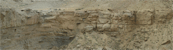 Cliff Face 1
Mosaic (169MB)
Cliff Face 1
Mosaic (169MB)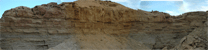 Cliff Face 1 & 2
Mosaic (264MB)
Cliff Face 1 & 2
Mosaic (264MB)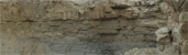 Cliff Face 2 & 3
Mosaic (184MB)
Cliff Face 2 & 3
Mosaic (184MB)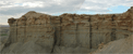 Cliff Face 3
Mosaic (64.6MB)
Cliff Face 3
Mosaic (64.6MB)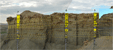 Cliff Face 1, 2 & 3 Mosaic with Measured Sections (173MB)
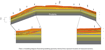 Bedding diagram of Cliff Face 1, 2 & 3 (153KB)
Cliff Face 4.1 Mosaic (2.9MB)
Cliff Face 4.2 Mosaic (2.6MB)
Cliff Face 4.3 Mosaic (3.4MB)
Cliff Face 4.4 Mosaic (2.3MB)
Cliff Face 4.5 Mosaic (3.1MB)
Cliff Face 5.1 Mosaic (2.4MB)
Cliff Face 5.2 Mosaic (4.6MB)
Cliff Face 7 & 9 Mosaic (2.5MB)
Cliff Face 8 Mosaic (1.3MB)
Cliff Face 10 Mosaic (4.7MB)
Cliff Face 12 Mosaic (2MB)
Cliff Face 13 (2MB)
Cliff Faces 5 & 6 Mosaic (1.9MB)
Cliff Faces 5, 6, & 7 Mosaic (3.6MB)
Cliff Faces 5, 6, 7, & 9 Mosaic (5.2MB)
Cliff Faces 6, 7, & 9 Mosaic (1.7MB)
Cliff Faces 7 & 8 Mosaic (1MB)
Cliff Faces 7 & 9 Mosaic (2.9MB)
Cliff Faces 10 & 11 Mosaic (2.7MB)
Cliff 7 Bedding Diagram (34.1MB)
Cliff 8 Bedding Diagram (11.7MB)
Cliff 9 Bedding Diagram (7.2MB)
Cliff Face 10 Bedding Diagram (212.1MB)
